Building an innovative Ethno-Geographic Information System (EGIS) to address opioid overdose disparities in Inland Southern California
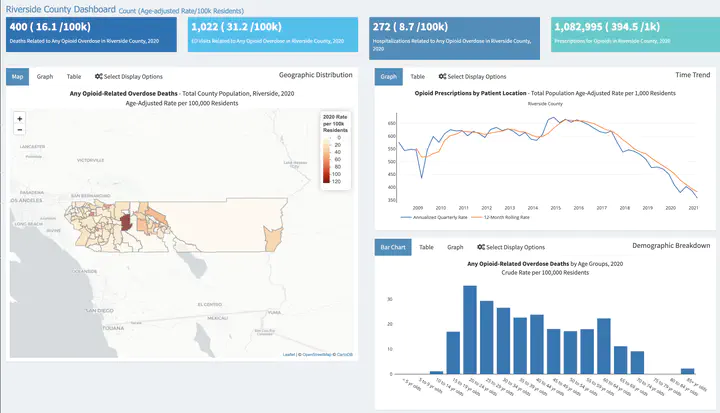
 Overdose Dashboard Built by Riverside County Public Health
In the United States, drug overdose is the leading cause of injury-related death. Nationally, narratives of opioid overdose as a predominantly White suburban crisis tell only a partial story, overshadowing the importance of local geosocial contexts in producing overdose disparities in marginalized and underserved communities. As one example, Riverside County is California’s third-largest in population, representing a socioeconomically, racially, and geographically diverse region characterized by widespread health disparities and a shortage of healthcare providers.
Overdose rates have been rising for more than a decade; nearly half of all overdoses are among non-White populations, and deaths have increased among Blacks by 30%, Native Americans by 47%, and Latinos by 52%, while 5-year average overdose rates are highest in several predominantly minority and rural communities beyond the county’s urban hub, the City of Riverside. We consider Riverside County as a “risk environment,” defined as the social and physical spaces where contextual factors interact to cluster harms among disadvantaged populations.
However, the spatial characteristics of overdose risk environments are not well characterized because current spatial models lack ethnographic granularity on how structural factors shape lived experiences of opioid use. Thus, we ask: how do we better characterize opioid overdose disparities to enhance our response across diverse social geographies? The overall goal of this project is to develop an innovative Ethno-Geographic Information System (EGIS) that combines ethnography with spatial analytics to characterize opioid overdose and guide research and resource allocation to reduce overdose disparities in underserved communities.
The specific aims of the project are to:
-
Develop spatially-explicit models relating epidemiologic indicators of opioid overdose (i.e., overdose mortality, EMS calls) to spatial contextual variables hypothesized to influence the risk of overdose. These models will combine to create a “risk surface” map of Riverside County and identify which aspects of spatial context are associated with opioid overdose disparities through the use of formal spatial analytical methods.
-
Examine the structural, social, and spatial contexts of overdose among a diverse sample of people who use opioids via ethnographic methods (observations, in-depth interviews, and ethnographic mapping). This work will build upon, contextualize, and reconsider the risk surface map developed in Aim 1 using on-the- ground data to explain observed opioid overdose disparities.
-
Integrate the geospatial and ethnographic data from Aims 1 and 2 to develop an Ethno-Geographic Information System (EGIS) that characterizes opioid overdose disparities to guide resource allocation and future research efforts focused on reducing disparities. Our research will provide an innovative new method, EGIS, to serve as a foundation for developing and testing community-level interventions to reduce overdose incidence and mortality in subsequent R01 grant proposals, and will provide a new tool for use by communities around the country to address opioid overdose disparities.
See more on the funder’s website
