Latest News
COGS director Sergio Rey will facilitate a Spatial Data Science Summit at the Berkeley Institute for Data Science (BIDS) on March 15-16, 2026. The summit will convene researchers, developers, educators, and community leaders to identify challenges and opportunities in the development of a more open, interoperable, and sustainable geospatial ecosystem.
COGS researcher Santiago José Elías Velasco joins a consortium of international biodiversity scholars in publishing an article in the Proceedings of the National Academy of Sciences. This article argues that the Kunming–Montreal Global Biodiversity Framework cannot meet its goals if it continues relying mostly on retrospective monitoring, and it calls for integrating predictive biodiversity models into conservation planning.
From the paper:
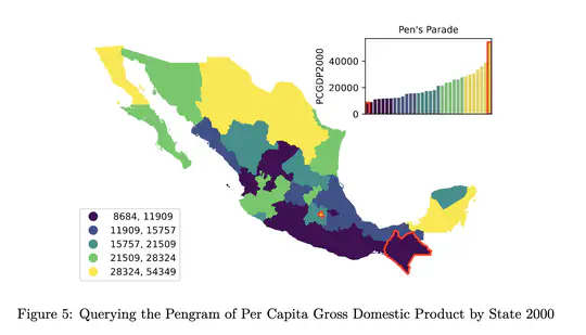
Abstract. This paper explores the concepts and computational methods used to measure spatial inequality, emphasizing a reproducible approach that social scientists can apply to their research. The analysis focuses on geographic income disparities at the sub-national level, using Mexico as a case study.
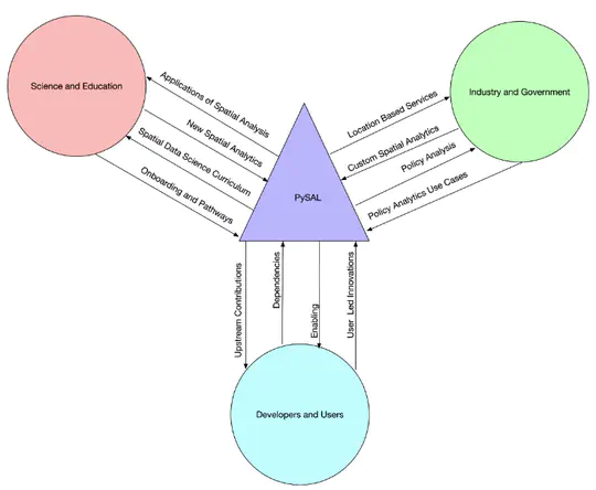
The COGS team has received a prestigious $1.5M award to transform the Python Spatial Analysis Library (PySAL) into a fully-fledged open-source ecosystem by engaging academia, government, and scientific partners. Read more on the grant page
Carli Henderson, a first-year M.S. student, sucessfully defended her research proposal titled “Geography of History: Mapping the Spatial Inequality of the National Register of Historic Places”. The project will focus on connections between historical redlining, segregation, and the National Register of Historic Places - the United States’ federal register of historic preservation.

From the paper:
Abstract. This paper explores the concepts and computational methods used to measure spatial inequality, emphasizing a reproducible approach that social scientists can apply to their research. The analysis focuses on geographic income disparities at the sub-national level, using Mexico as a case study.
Supported by COGS and CNNCTS, Dr. Janet Franklin brought Mr. Connor Magee into her class, Geography 570: Environmental Conservation Practice – Social-ecological Impacts of Climate Change on March 12, 2025. Connor Magee is an ecology Ph.

Dr. Janet Franklin recruited distinguished remote sensing scientist Dr Compton J. Tucker, from NASA Goddard Space Flight Center to give a research seminar at SDSU on November 8 2024 entitled “A tool to address restoration efforts and the role of trees outside of forests in rural livelihoods: Mapping African semi-arid trees at the tree level south of the Sahara & north of the Equator.

On October 14, 2024, San Diego State University geographer Janet Franklin was invited to give the 13th Virginia & J. Edward Holtry Distinguished Lecture in Geospatial Science at ‘the other SDSU’ – South Dakota State University.

In a new paper published in Applied Spatial Analysis and Policy, SASS scholars show the importance of considering features overlapping spaces when measuring racial residential segregation.
