Scalable Geospatial Analytics for Social Science Research
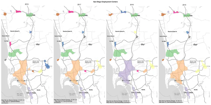
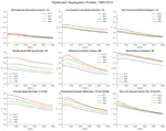
The project’s goals are to enhance the open source spatial analysis library PySAL in four main directions. The first innovation concerns new methods for the treatment of uncertainty in the American Community Survey data. Second, a new framework for statistical inference in the space-time analysis of segregation will be developed. Third, scalable algorithms for regionalization and spatially explicit aggregation of areal units will be produced. Finally, the project will develop a new scalable spatio-temporal data management layer to support the application of these three sets of analytics to large datasets. The software developed here will be included in enhanced (and new) modules in PySAL. This will afford the development of new types of applications using different interfaces from plug-ins for desktop GIS, both open source and proprietary, to the development of software as service systems and the ability of installations where on-premise requirements are binding (Census Research Data Centers). This portfolio of use cases will support a wide range of scientific disciplines and will provide direct benefits to society through new geospatial tools that will improve the state of the art in urban planning, economic development, and spatial public policy.
See more on the funder’s website
Sergio Rey
Director and Professor
My research interests include geographic information science, spatial inequality dynamics, regional science, spatial econometrics, and spatial data science.
Ran Wei
Associate Professor
My research interests lie in the development and implementation of GIScience methods and techniques to address substantive social and environmental problems
Elijah Knaap
Assistant Professor
My research interests include urban inequality, neighborhood dynamics, housing markets, spatial data science, regional science, and housing & land policy.